Real-time Analytics
Metrics and performance data for MapaTica
Timeframe:
Advanced Analytics
Monthly Growth
Percentage change in user base over the last 30 days compared to previous period
Category Ranking
Current position ranking within the extension category compared to competitors
Install Velocity
Average number of new installations per week based on recent growth trends
Performance Score
Composite score based on rating, review engagement, and user adoption metrics
Version Analytics
Update frequency pattern and time since last version release
Performance Trends
Analytics data over time for MapaTica
Loading analytics data...
About This Extension
Comprehensive Costa Rica mapping - for conservationists, government officials, realtors, developers, surveyors, and property owners.
The best solution for online mapping in Costa Rica. MapaTica integrates with SIRI and adds features to make it easier to research properties.
* En ingles y espanol
* Cleaned up and more usable interface
* Select properties on map
* Search by GPS coordinates, property id
* 50+ overlay useful layers (terrain, water, roads, satellite, etc, as well as SETENA, AYA, IGN and other agency data)
* Boundary - check whether SIRI has the correct boundaries for your property
* Integrated with the national registry - click on property to get property details from registry
* Useful drawing tools
* Import / Export to KML, allowing interaction with Google Earth
* Import / Export to GPX, allowing you to view locations on OSMAnd or other mapping apps on your phone; also useful for importing observed locations back into SIRI
Screenshots
1 of 1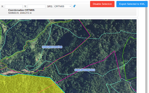
Technical Information
- Size
- 8.56MiB
- Languages
- 1 supported
- Extension ID
- dbplkdfbbcak...
Version History
2.2.14
Current Version
Latest
11/04/2025
2.2.13
Previous Version
10/05/2025
2.2.12
Older Version
09/05/2025
Related Extensions
Similar extensions in Tools
GoFullPage - Full Page Screen Capture
by Full Page LLC
Developer Tools
Capture a screenshot of your current page in entirety and reliably—without requesting any extra permissions!
10.0M
4.9
82.5K
Mar 23
View Analytics
TouchEn PC보안 확장
by 라온시큐어
Developer Tools
브라우저에서 라온시큐어의 PC보안 기능을 사용하기 위한 확장 프로그램입니다.
9.0M
1.3
6.2K
May 23
View Analytics
WPS PDF - Read, Edit, Fill, Convert, and AI Chat PDF with Ease
by www.wps.com
Tools
Easy-to-use PDF tools to view, edit, convert, fill, e-sign PDF files, and more in your browser.
8.0M
4.5
146
Sep 29
View Analytics