Real-time Analytics
Metrics and performance data for Earthquake Monitor
Timeframe:
Advanced Analytics
Monthly Growth
Percentage change in user base over the last 30 days compared to previous period
Category Ranking
Current position ranking within the extension category compared to competitors
Install Velocity
Average number of new installations per week based on recent growth trends
Performance Score
Composite score based on rating, review engagement, and user adoption metrics
Version Analytics
Update frequency pattern and time since last version release
Performance Trends
Analytics data over time for Earthquake Monitor
Loading analytics data...
About This Extension
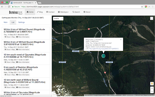
Shows earthquakes from USGS, GeoNet, BGS, GeoScience Australia and EMCS on a Google Maps backdrop.
Monitor earthquakes around the world including US Geological Survey, New Zealand GeoNet, UK BGS, EMCS, Natural Resources Canada, Indonesia Tsunami Early Warning, GFZ Potsdam, National Observatory of Athens,Istituto Nazionale Di Geofisica E Vulcanologia, and Geoscience Australia. It shows earthquake icons with tool tips on a Google Maps backdrop. The icon will look more transparent the older the event was published. There is also a list view which can be used to sort the earthquake events according to the date/time, region, and disaster type. Clicking on the icon will bring up more details about the event.
Screenshots
1 of 3
Technical Information
- Size
- 15.68KiB
- Languages
- 1 supported
- Extension ID
- hicnbeaahmei...
Links & Resources
Version History
1.2.3
Current Version
Latest
12/05/2023
1.2.2
Previous Version
11/05/2023
1.2.1
Older Version
10/06/2023
Related Extensions
Similar extensions in News & Weather
RSS Feed Reader
by Really Simple i Stockholm AB
News & Weather
Get a simple overview of your RSS and Atom feeds in the toolbar
500.0K
4.4
7.2K
May 9
View Analytics
RSS Subscription Extension (by Google)
by [email protected]
News & Weather
Adds one-click subscription to your toolbar.
500.0K
4.0
3.5K
Jul 4
View Analytics
Yahoo Homepage
by YAHOO INC.
News & Weather
Stay informed with the stories that matter most to you. This extension sets Yahoo.com as your homepage and New Tab page.
400.0K
3.7
70
Oct 24
View Analytics